Death Valley National Park, and its associated mountain ranges and intervening valleys, is located in the (north)eastern Mojave Desert just north of Baker, California, and east of Beatty, Nevada. Death Valley is at the southwestern corner of the Basin and Range Province, characterized by a series of north-south trending mountain ranges and intervening valleys. Death Valley and the adjoining mountain ranges trend on a nearly north-south axis.
The Panamint Range forms the west side of the valley. Telescope Peak is the highest point at 11,049 feet above mean sea level in the Panamint Range overlooking the west side of the valley. The Panamint Range consists of a series of mountains, from north to south, the Cottonwood Mountains, Tucki Mountain, and the Owl Head and Quail Mountains at the south end. Ubehebe Crater occurs at the north end of the Cottonwood Mountains.
The Amargosa Range bounds Death Valley on the east. The Amargosa Range consists of several mountains, including, from north to south, the Grapevine Mountains, Funeral Mountains, Greenwater Range, and Black Mountains.
Death Valley, at Badwater, is the lowest spot in North America at 282 feet below mean sea level. Death Valley contained one of the largest lakes in California during the Pleistocene, over 10,000 years ago, containing Pleistocene Lake Manley, which partially reformed in the 2004-2005 winter. Furnace Creek and Devil's Golf Coarse are both located at the bottom of the Pleistocene Lake Manley, which is fed by the Amargosa River. The Mojave River once also fed the Pleistocene era lake.
The landscape of Death Valley is typically a stark arid landscape with extreme high summer temperatures well over 100 degrees Fahrenheit. The geologic formations are what define Death Valley most of the time. However, during the rare wet year, such as the 2004-2005 rainyear, the wildflowers transform this stark landscape into seas of flowers. And on even rarer occasions, Lake Manley starts to refill, at least to a foot or two deep, starting at Badwater, the lowest spot in Death Valley (-282 feet).
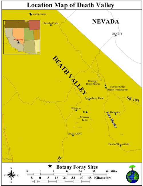
Areas of Death Valley explored on the following pages include: Ballarat in the Panamint Valley, Wildrose Canyon, Aguereberry Point, and the Charcoal Kilns in the Panamint Range; the Harmony Borax Works, Stovepipe, Furnace Creek, Devil's Golf Coarse, Badwater, and the Ashford Mills area of the valley floor; Ubehebe Crater at the north end of the Cottonwood Mountains (north end of Panamint Range); the Eureka Dunes in the Eureka Valley on the northwest end of the Park; and the west edge of the Black Mountains and Jubilee Pass. Also shown are scenes of Silver (Dry) Lake north of Baker in a not-so-dry condition.
All photographs copyrighted by David L. Magney 2005